Welcome to our locality page! Here you will find out more about the Rusheen area and Aghinagh Parish.
| Here is a Contour Map of our area. We painted it ourselves. As can be seen the darker colours represent the higher terrain in our locality. (Burren and Coopers Rock).There is a great variation in height from over 1000ft on top of Burren to 200ft at The Metal Bridge. Because of this there is a great diversity in the habitats in the Rusheen area which obviously means a great variety in our wildlife.Rusheen School is 600ft above sea-level. | 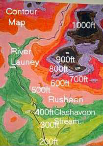 |
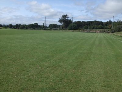
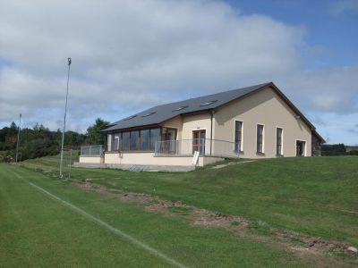
Gaelic Football is an important sport in Aghinagh. Gaelic games have been played in the Parish since the 1890s when hurling was the dominant game. The Club as we know it was founded in 1949. It has its pitch in Rusheen and it’s colours are blue and white.
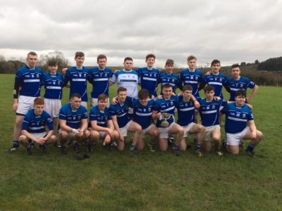
Aghinagh County Minor Championship Winning Team
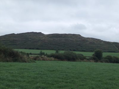
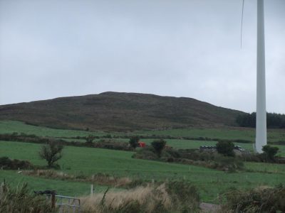
There are some lovely walks around the Rusheen Area. Here is one of them which circles Coopers Rock. The height of Cooper’s Rock is 991 ft. It is a rough craggy heap of sandstone just south of Burren Mountain (1250ft). There is a neat well-built cairn on the summit and this makes it easily recognisable from near and far.
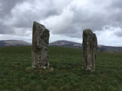
If you start walking at Laghnahaghny Cross towards Rusheen Cooper’s Rock itself appears on your left and it’s topping cairn is clearly visible and then, just as the road swings left, in the field on your right is a pair of magnificent standing stones. Back to the road, which begins to fall as it crosses a little fast-flowing stream, take the road to the left and up a sharp climb (The High Road) . Soon you come to a derelict stone house on your left shortly beyond which is an opening into a field. This is the best point to take off for your trip to the top of Cooper’s Rock. Just go straight up following the stony path and in about 10 minutes you are there. Having returned to the road turn left as you emerge from the field and go with the fall of ground to a cluster of trees, an attractive entrance and avenue on your right (Rockville) and a little further on a large cream-coloured house on your left. Take the road to the left immediately before this house and follow it up a fairly steep climb for about 0.5 miles until you see ahead of you a cottage immediately before which is a junction left which you take. At the highest point of the road where it swings left look over the rusty 6-bar gate towards the north-east. Continue your way downhill, noting the forestry on your left until you join a wider road on to which you turn left walking along through the forestry on each side (Lyravouig). Continue for over a mile down to Lacknahaghny Cross to finish your walk.
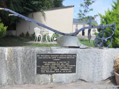
Ploughing is a big sport in our area are and an important activity around the parish of Aghinagh. Ploughing matches are held in Macroom, Bandon, Kanturk, Clonkilty, and many more places in West and East of Cork. Jerry Horgan was a good plough man and in 1971 he won his first All- Ireland and in 1986 he won his last All- Ireland. J.J. Delaney from Cahebaroule won the All- Ireland Senior Horse Ploughing in 1995 representing Cork in Co. Laois.The most recent All- Ireland was in Co. Cork in Castletownroche. There is big interest in tractor ploughing as well. Pat Casey Curraghawaddra is very interested in ploughing and won the over forties in Macroom Ploughing match.
This is the plough Jerry Horgan won the All-Ireland with.
Bowlplaying or road bowling, as it is sometimes called, is very little known outside the counties of Cork and Armagh. It is also played on a small scale in Waterford and a little in Limerick. The method of throwing the bowl in Armagh differs from the Cork bowlplayers way of throwing the 28oz. Ball. The southern player winds his arm fully and the Armagh only takes a half a swing. Some people seem to think it came from Scotland in days gone by. This may be, because some of the earliest bowls came from Scotland. They were smaller than the present day 28oz. bowl but they were more compact and a nicer bowl to play with. They weighed the full 28oz. There are many great bowlplayers but Mick Barry, from Cork, had the honour of being King of the bowlplayers. Scores now carry very high stakes, which probably takes a lot of sport out of the game when too much money is involved. Bowlplaying was always popluar in Mid-Cork, very much so in Aghinagh. Ballinagree has often been referred to as the home of bowlplaying. A lot of bowling is done in Bealnamorrive as well.
Aghinagh Parish is situated at the foot of the Boggeragh Mountains, in the Barony of East Muskerry. It consists of 21,169 acres and stretches for about ten miles to the North from the River Lee at Carrigdrohid, and it is about four miles in an east west direction.
This area has been inhabited for a long time, for scattered across the length and breadth of this parish from its highest hills to its deepest valleys is evidence of human activity, dating back almost 4,000 years. Almost every farm in this area has some form of stone age monument.There are many possible explanations of the name Aghinagh such as that Aghinagh originally belonged to Aghinagh a grandson of Laoghaire. Another explanation is “AthTheinne”. That is “Ford of Fire ”. Tim Gleeson writing in Cork Archaoelogical Journal of 1893 suggests that Aghinagh means “The Ivy covered field”. Even within the parish we have Ard Eidhinn Cross which means “Height of the Ivy”. There are four villages in the parish of Aghinagh. They are Rusheen, Bealnamarbh, Ballinagree and Carrigdrohid.Rusheen is in the middle and is our village.
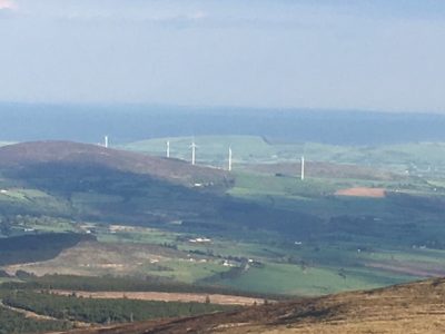
A view of the Parish of Aghinagh from the top of Mushera
The Aghinagh way is a historical trail of Aghinagh. It is full of monuments. It consists of:
It was set up by the “Aghinagh Heritage Group”. It is a route for walking, cycling or driving. If you look around Aghinagh you will find lots of maps of the ” Aghinagh Way” at Rusheen ,Ballinamorrive, Ballinagree and at the Butter Road Millstreet. You have a choice of going on the hill cycle, the lowland cycle or on the heritage drive to places of interest. Read below about one of these interesting sites.
The earliest record of a church in Aghina (achynach) is 1451.The Parish Priest at the time was Fr. Lactinus O’ Longagh (1451-1457). The first record of a church on this site is 1656.”That the Parochial Church of Aghina stands near the Lee.”It is unroofed and nothing remains but the walls. It is surrounded by about twenty acres of Glebe land, the fence of which is also in bad repair”. This was probably the reformation church.
In 1774 the church was still in ruins .In 1785 the Protestant population was only 21.By 1830 45 years later it had risen to119. It must have been this rising trend in population that encouraged the building of the church. And so in 1791, Aghina church was rebuilt, capable of holding 130 persons. It cost four hundred and sixty one pounds-10-9 1/4 to build and was dedicated to St. Ruadhan. Church of Ireland Records claim that the”Bishops Head” carved on to the Tower was probably meant for him. It may also be a relic from the pre-reformation Church of Aghinagh.However to quote the late Patrick Hubbard well known authority on local history (In Contact 79″.”Legend says that Cromwells soldiers took the dead Bishops mitre (Bishop Mc Egan, hanged at Carrigadrohid 11/5/1650) and placed it on the window of Aghinagh Church, facing the road and stood outside the gate taking pot shots at it with their muskets. They then carved an image of it in stone and placed there in mockery”. In 1791, when the present building replaced the old one, it was built into the front wall, not as a mockery now but as a memorial.
Ruisin means little wood.At the southside is Cusheen Wood which gives the townland its name.The village consists of a pitch ,a church , a shop , a hall , a school , an old creamery ( now a recording studio), an old R.I.C. barracks (now inhabited), a disused forge and a number of houses. The townlands around Rusheen are Coolkisha, Kilberrihert, Aughinida, Knockglass, Deelish , Caherbaroule Clonavrick,Derryroe,Shanakiel,Knockeenacuttin,Drombeg, Dromduve,Coolnadane,Curraghanearla and Dromree.
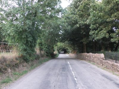
The Wood Road Rusheen
Recently we did a project about all the historical buildings in Rusheen and on this page you will find some articles from the book we produced.
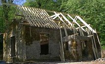
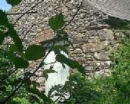
The Old Protestant Church was the first place we visited on our Heritage Trip. It is situated in Cusheen Wood. This wood gives Rusheen its name because the Irish for Rusheen is “Rúisin” and this means “little wood”. The Building was in bad repair until recently. When we visited there were builders working. We met the owner, Mrs Claire Coleman, and we were delighted to get a guided tour. Now it is going to be used as a dwelling house and a B&B. The walls which are the original ones, were built with stone and are in very good condition. There is a new slate roof being put on now The Church consisted of one big room and a porch. There was a fire-place in the big room to heat up the church. What impressed us most about the church was the beautiful stonework of the walls. Also the windows are wider outside than inside. The lintels of the doors and windows are made of a number of flat stones fitted together to make an arch. The Church was the center of worship for the landlords and other Protestants who lived in the area. The most prominent of these would have been the Woodleys from Leeds House, Radleys from Rockville, Brodericks from Kilberrihert House and the Bowens from Hanover Hall. When the Church closed some of its pews were donated to the local Catholic Church in Rusheen and can still be seen there today. Local tradition has it that one of the carpenters who worked on the building of the church was Philip Allen. He was one of the Manchester Martyrs who was hanged at Manchester in 1867 along with Larkin and O’Brien for the killing of a police sergeant during a raid on a prison van. The Manchester Martyrs were part of “The Fenians”, a militant group who tried to win independence for Ireland in a failed rising in 1867.
This is a photo of the forge taken by us on our heritage trip, March 2001.
The forge is situated just South of the School in Rusheen. It is now disused but is owned by Mr. O Connor who lives nearby. It is a beautiful, old stone building but none of the tools remain there. The Blacksmith that worked in the forge long ago was Den Linehan. Up until the 1960’s the forge was very essential in rural communities, as the services of the Blacksmith were required by nearly every member of the community in which he worked. The blacksmith’s jobs varied: he shod horses, but he also made troughs, tools for the community, cranes and hooks for fireplaces, spades, sickles, scythes and also gates. The work of shoeing the animals began by the reddening of a thin iron bar on a fire of slack coal on a hob, which would be kept alight by the turning of a handle on a bellows. The iron would then be beaten into the required shape on an anvil and cut if necessary to the desired length using a chisel and a hammer or sledge. Holes would then be made in the shoe for the nails to be put through. The shoe would then be reddened on the fire and placed on the animals hoof and it would burn its shape onto the hoof. The shoe was then cooled in water and the animals hoof pared. Then the shoe was carefully nailed to the horses hoof. The forge was a good meeting place and all the local social issues would have been discussed there. Money was is short supply in those times and payment was often a form of bartering i.e. a sack of potatoes or a piece of meat might be given by the person requiring the services of the blacksmith.
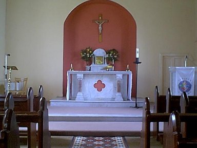
Rusheen Catholic Church is in the townland of Kilberrihert. It is a small Church and is one of three in the Parish of Aghinagh. Why a Parish as small as Aghinagh would have three Churches cannot be explained unless we examine our ancient history going back to the 1840s. Then there was no Church in Rusheen. In the townland of Aughinida near Rusheen was a little tatched Chapel where the local people worshipped. This Chapel was situated on the Shanakiel side of the Barracks Cross. Eventually this little Church fell into disrepair and a new Church was proposed to serve the needs of Rusheen and Ballinamorrive. Fr. Pearse Green was the Parish Priest at this time and a site was offered to him in Ballinamorrive. A Church built here would suit the people quite well, but the people of Rusheen protested that it was too far from them. However, work commenced on the new Church in Ballinamorrive. So annoyed were the people of Rusheen that they attached the partly built Church. They were driven off, but returned in force sometime later and a battle took place between the two factions. All kinds of weapons were used and one of the attackers was stabbed. The walls were razed to the ground and the building abandoned. Two of the attacking families were excommunicated and there were a number of court cases which made the headlines of the local newspapers. During this time, the people of Rusheen did not recognise Fr. Green as P.P. and had a suspended Priest named Fr. Mulholland doing duty for them. The issue was finally settled by the building of two Churches, one in Ballinamorrive and one in Kilberrihert for the Rusheen people. The site for the Church in Kilberrihert was given by a local Protstant Landlord, Mr. Cooper.
The question of how the parish hall came to be has often been asked. It’s location was decided at a meeting in Bealnamorrive on 13th February, 1950. In the 1940’s Muintir na Eire, under the guidance of its founder, Conan Hayes of Bansha, founded parish councils in most rural areas. In 1947 the clergy then in our parish, Fr. Twomey P.P. and Fr. Driscoll C.C., decided that a guild or a parish council would be a good idea in Aghinagh. The parish council in discussing the provision of a meeting place at first decided to purchase a nissen hut and in fact had almost bought a hut in Dublin for £65 plus carriage of £11 but eventually decided to erect a more substantial structure. A public meeting was held in Bealnamorrive. At this meeting a proposal that a hall be built in Rusheen was put forth. The site was three or four feet under road level. It required an enormous amount of stones to bring it up to road level. Despite an all out campaign to raise money for the fund the council was still far short of the amount needed. So it was decided to raise a loan. Allied Irish Bank refused but the Bank of Ireland agreed a loan of £200 provided that five guarantors with a valuation of over £5 could be got. A gala opening cermony was held on the third Sunday of December 1950. Delegates were present from all parishes in the Mid-Cork area. Subsequently in Fr. Hegarty’s time extensions and alterations were carried out..
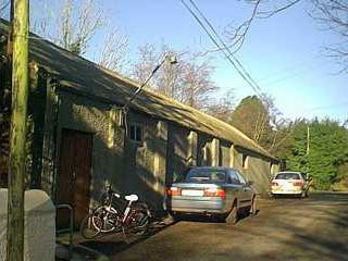
The creamery is situated at a fork in the road, above Coopers Cross, in the townland of Rusheen . It was built in the 1930’s. It is no longer used as a creamery having been closed down in the early 1970’s. In its hey-day all the local farmers brought their milk to Rusheen creamery. In the earlier times , the milk was brought by donkey and cart, then as the farmers grew richer milk was brought by horse and cart and eventually by tractors and trailers. The farmers’ milk was brought in churns. The milk was poured into a big tank to be measured and the farmers were paid for their milk at the end of the month. The farmers could also buy feed for their animals in a separate shed. Afterwards, farmers could go to the shop nearby. Here they could buy bread, newspaper etc. and have a chat with other farmers. It was a great social occasion for them. When the creamery was closed, it lay unoccupied for some time. However, it was then bought by Adrian Lacey-Porter and John Pettey and they set about developing “Tribarac Recording Studios”. Now the upstairs of the creamery has been converted into a state of the art 48- track digital recording studio. Downstairs has been developed as a multi-use rehearsal facility with a stage, available for hire as a work-shop, party or function space for 100 plus people. The studio is connected to the World Wide Web allowing access to millions of sound effects.
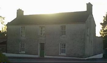
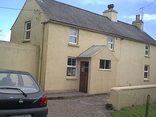
The Barracks Cross is in the Southern part of Rusheen .It gets it’s name from the R.I.C. Barracks that stands there .This building is now used as a dwelling house by Mr. John Leary and his brother Dan Leary .There are still bars on the bottom two windows .The officers lived there and the patrolled the area . They would have been particularly busy at the time of the great trouble during the building of the new Church in Rusheen. You can read all about it in our article on Rusheen Catholic Church. It is a two storey house 15 meters long and 13 metres wide. There is a high wall built at the back of the house and a farmyard beside it .It is built near a Protestant Church.
This is a picture of Eileen Cronin’s shop, which is now closed. It is by the church. There was also a shop near the creamery owned by Matt and Kathleen Kelleher but that is also closed.
Kilberrihert
Cill Berchert = St. Berrihert’s Church. It has 943 acres.Remain’s of Berrihert’s Church are still visible at the south side, and also a ring fort with souterrain. Here are cromlechs called Uaigh an tSaighdiura – Soldiers grave and Páirc na Lice – Field of the Flag Stone. North end is termed Cahernafulla – Cathair na Fola (bloddy stone fort). Local tradition says there is a connection between Cahernafulla, Lyravouig (fork of the victory) in Dooneens townland and Bealnamorrive. A battle was fought, seemingly, at Cahernnfulla and victory celebrated at Lyravouig and the Glashagarriff stream is supposed to have been reddened to Bealnamorrive (mouth of the dead). A passage connecting Cooperville and Rusheen Catholic church is termed An Poirsin – Narrow road.
Rusheen
Rúisín = Little Copse. It has 288 acres. At the south side is Cusheen Wood – Cabhaisin (little causeway) as well as the remains of a dolmen. Here also are ruins of an old Protestant church which was closed in or about 1912.
Lacknahaghny
Leacain a’ hEachaidhe = Hillside of the horseman. It has 370 acres. South side is termed Burren – Boireann (rocky spot).
Burren Hill
Deelish
Duibh Lios = Black or dark fort. It has 341 acres. In the centre is a large ring fort.
Knockeenacuttin
Cnoicnín a’Choithinn = Little hill of the commonage or common grazing. It has 159 acres.
Curraghanearla
Currach an Iarla – Earl’s marsh. It is sometimes called Earlville. It has 439 acres.
Dromree
Drom Rí – The Kings Ridge or Hill
Coolnadane
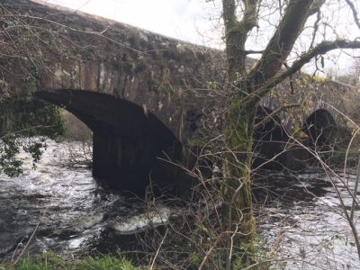
Clonavrick
It has 313 acres. Cluain Ui Mhic Broic – Plain of the Ui Mhic Broic. This was a tribe descended from Corc, King of Cashel .
Clonavrick Bridge
Knockglass
Dromduve
Dromdubh=Blackridge. Near Dromduve is Hanover Hall home of the ledgendary Morris who was responsible for the death of Art O’ Leary.
Aughinida
Ath an Fheide = Ford of the streamlet. It has 255 acres. At the east side on the Clashavoon stream – Clais a’Mhuin (vale of the putrid water or probably of the weeds) is Aughnavar – Ath na BhFear (ford of the men). Nearby is a site of a ring fort with souterrain. The name of popular landlords (Cooper) is preserved in Cooperville in this townland. Cooper’s Rock in Kilberrihert and Cooper’s Cross in Rusheen.
Clashavoon Stream
Shanakiell
Sheana-Chill = place of old church. Adjacent to Shanakiel Cross-roads at the north side is the site of an old church. In the townland are two ring forts. It has 468 acres.
Drombeg
(347acres)Drombeag =Little ridge or hill-back. At the south-west is a road called Barnageehy – Bearna Gaoithe (windy gap). South side is termed Knockagreenane – Cnoc a’Ghrianain (the sunny hill).
Coolkisha
Coolkisha Cuil Cise=Nook Of The Wickerwork Bridge. It has 296 acres. There are two ringforts in the townlands. At the west side is Carrigaclodig Cross-roads – Carraig a’Chladaigh – Rock of the stream chanel. Remains of two dolmens are nearby. On the south border is Awfund Bridge – Ath Fionn (white ford).
Derryroe
Derryroe. Doire Ruadh=Red Oakwood. The Red Well (Tobar Dearg), at which rounds are preformed, is in Derryroe. It is also known as St. Berrihert’s Well. The townland of Derryroe has 500 acres.
Caherbaroule
Caherbaroule – Cathair Baramhail – Stone fort of the person of judgement/or fixed opinion. Baramhail was a nickname applied to some McCarthy famliies in Muskerry and described a person of sense. Traces of the old stone fort with southerrain exist at the south side and also a cross-inscribed stone. Further north are two heavy standing stones a dozen feet apart. Nearby are remains of a pre-historic dwelling or beehive-shaped house believed to be up to two thousand years old. Remains of a dolmen are at the east side. It has 426 acres.
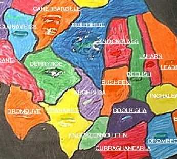
This is a map of our local townlands which we drew and painted.
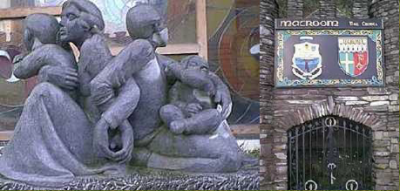
On the left is “The Family-Spirit Of Macroom Scilpture” presented to the town by Mr. Dermot Desmond. On the right is the miniature castle and crest at Hartnetts Cross.
Macroom is our nearest town and is about 4 miles away. The Irish for Macroom is Magh Cromtha. It means The “Hilly Plain”. Macroom’s population is about 2000. There are four big food stores in Macroom. Their names are Spar, Dunnes Stores, Lidl and Aldi. Bealick Mill is in Macroom.It is a multi story Corn mill built in the early 19 century. In 1989 a group of people came together with a dream of developing it as a centre for the community and focal point for vistors to the Lee Valley area. On Tuesdays Macroom has street trading, and attracts a lot of Natives and Tourists. Typically the market features stalls selling everything from clothes and shoes veg, fruits tools and a wealth of potential second-hand bargains. It has a new Library and Cinema called The Briery Gap which cost 750,000 pounds to build a few years ago. The Danone Baby Food factory employs a lot of people in the area. Just two miles south of the town in the beautiful Lee Valley is the Gearagh Wildlife Nature Reserve which proves to be an ideal spot for studying everything from otters, foxes and badgers to kingfishers and whooping swans. Visitors love spending time browsing in the craft and design shops here which offer a great variety of unique and hand-crafted Irish goods. Excellent 18-hole courses for both golf and pitch’n’ putt are to be found within minutes of the town centre.